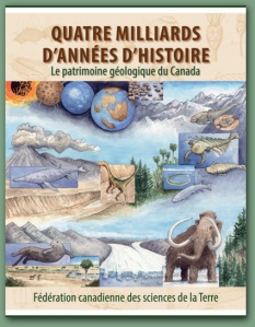

Just published! 400-pages on Canada’s geologic heritage in both official languages for only $39.95! Order your English language copy here and your French copy here.
The book’s website has tons of freely downloadable illustrations and other materials for educators
—–
One day last summer, a 40-ish well-educated woman visited our house. She makes a living in gastronomy, is a good visual artist and an avid ocean sailor. She asked me about my professional background and I told her that I am an earth scientist. She looked puzzled and said: “and what do you do with that, other than teach?”
Ai…….
I was dumbstruck for only a second, then noticed her nice shiny and stylish watch and said “well, let’s begin with your watch, where do you think its component materials came from?” Then it was her turn to look puzzled. And so evolved a conversation about steel, nickel, Sudbury, and on about the diesel that fueled the bus that she had taken that morning and about earthquakes that may cause tsunamis in her beloved Pacific Ocean.
This little incident is only one reason why we need earth science outreach products for the general public and why we as a society must cherish and promote recognition of and access to our shared geoheritage (here is an earlier post that I devoted to geoheritage in Canada).
“Four Billion Years and Counting” (4BY) is one of those products. What is unique about this book is that it’s only one of two products that covers all of Canada, the other one being a book called “Canada Rocks”, which came out in 2007 as the tangible result of the CBC television series with the same name. But unlike “Canada Rocks”, 4BY came out in both French and English at the same time, a fantastic accomplishment.
4BY is the result of eight years of work by more than 100 geoscientist authors from all over the country (full disclosure: I had a small role in the production of the book, but none in putting its content together). So yes, a book written by a committee! About 25% of the book’s authors are women. Given that Canadian Universities employ just over 20% women in academic positions in earth science departments, this is encouraging.
4BY is also, in a way, a sequel to “The last Billion Years”, a book about the geoheritage of Canada’s Maritime provinces, which came out in 2001, is now in its 10th print run and continues to sell steadily. That success was the reason for its editors to start researching a similar product that would cover the geoheritage of our entire enormous and geologically complex and fascinating country. 4BY is the result.
But starting from the history of the success of “The Last Billion Years” also carried a risk: that book came out 4 years before Google Earth was launched. Everyone who has a remote interest in the earth has Google Earth on their digital device of choice. Together with every earth science prof in the world, I started using it in my classes right away and life became different from that magical moment in 2005. Many earth science organizations now include linkages to Google Earth. For example, the Ontario Geological Survey allows you to download their geologic maps over your own Google Earth software. Just go here and click on ‘download bedrock geology’ and the bedrock geological map of Ontario will open over your own Google Earth.
I know that this is a book and not a software system. But I don’t really see how a book like this can go without even referring to Google Earth once. Or to Aeromagnetic surveying, a crucial technology for understanding tectonic history and – ultimately – for finding mineral resources of which we know that Canada has lots. The book does have introductions about multibeam bathymetric mapping and about seismic surveying, however.

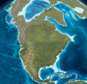
North America in the middle Miocene, ca. 15 million years ago. Image as in the book, from the image database by Ron Blakey
While 4BY is not intended as a textbook, it is organized as one: part I (15% of the book) covers the Foundations of geologic science, part II (50%) the Evolution of Canada, and part III (35%) is called Wealth and Health and pertains to the practical applications of geology to our economic and physical well-being. Wealth and Health has chapters on Canada’s Mineral Resources, Energy resources (coal, hydrocarbons, uranium and a tiny section on renewables), a wonderful section on building stones with a special inset about the building stones of Québec City, an extensive chapter on water resources, one that covers all the aspects of coasts (erosion, management, etc.), one on earthquakes (and landslides and tsunamis), one on impacts from outer space (I happen to have a post about those here), and one on environmental challenges. I think I’d recommend every neophyte geoscientist reader to start with this third part of the book, because – like our visitor last summer – that’s where the uninitiated reader gets the idea that this stuff just might be relevant for …….. well… their wealth and health!
The book is aimed at the general public so its language had to be carefully crafted to be both understandable and inviting. Most chapter and section headings certainly accomplish that. Wouldn’t you be curious to read on after headings entitled “Spheres of Influence”, “Continental bulldozer”, “Hell on Earth” or “Rolling up the Rim”? However, the text itself does require a reasonably initiated person, because it is in places rich in jargon. Fortunately there is an exhaustive index.
The photographs are a lust for the eyes: hundreds of pictures were submitted by armies of happy snap-shooting earth scientists, so the editors (one of whom is an accomplished photographer himself) were able to select the very best ones from a true horn of plenty. It is an appetite-wetting virtual geologic road trip through our country. There are also portraits of famous Canadian geoscientists, going back to 18th century Abraham Gesner, but I did miss a portrait of the great (20th century) J. Tuzo Wilson. In addition to photographs, there are dozens of explanatory diagrams and quite a few artwork reproductions. Especially the latter are worth mentioning: some of them are from museums, so we get to look at images of spectacular museum dioramas of and of the iconic Beringia paintings of George “Rinaldo” Teichmann. The paleogeographic maps are all by Ron Blakey, certainly the best.
The book will be accompanied by a website, which isn’t up yet. I understand that the website will be targeted especially to teachers and I can see that this book will be extremely valuable, together with the website, for high school science / earth science / evolutionary biology classes. I look forward to the site, because together with the site, the body of work may become a little easier to navigate. I missed that figures aren’t numbered and when the text refers to a certain section, it will not give the page number of that section. Many pages contain a string of places names, assuming that the reader knows exactly where those are. Most average citizens don’t, so a bit more geographic indexing would be helpful. As for me, I studied the book while sitting behind my computer and using the superb Atlas of Canada for finding my way around.
Overall, this is a exceptional contribution to the documentation of our amazing Canadian geoheritage legacy and I encourage everyone to buy this book pronto, for yourself and for whoever is on your gift-giving list.
===
update September 14, 2015: the book was also reviewed by Arthur Tingley for the Geological Society of London

