We hiked, the other day – a well-known coastal trail, but new to me. So much still to discover here and it’s not like we haven’t been trying. The trail is in Crystal Crescent Beach Provincial Park and takes the hiker all the way around the Pennant Point peninsula in about 4 hours.

Location of the Pennant Point peninsula, which sits as a veritable appendix off the Halifax peninsula. Inset: detail showing the tip of the peninsula (Pennant Point itself). Meaning of red star discussed below. Both images Google Earth
It’s an extraordinary beautiful area and wonderful for hiking as it hardly ever gets too hot or buggy thanks to ocean breezes and fog. The rocks and the landscape tell a fascinating story. It’s really too bad that there isn’t a single interpretive panel at the trail head.
The peninsula is exposed in striking almost-white granites and granodiorites (igneous rocks). They are peraluminous, meaning that their proportion of Aluminum oxide is relatively high compared to other granitic rocks. These granites are part of a large intrusive body, called the South Mountain Batholith. A batholith is a rock body that solidified from a molten magma as it cooled and moved upward towards the earth’s surface. A batholith consists therefore always of igneous rock and most batholiths are members of the granite family. Because of the excess Aluminum, peraluminous granites look very white, hence ‘leuco’ (meaning ‘light’).

Simplified map showing the extent of the South Mountain Batholith in Nova Scotia. Black arrow points to Pennant Point Peninsula. Total length of Nova Scotia is about 550 km.
The South Mountain Batholith rose and cooled in the Devonian, ca. 375 million years ago, a result of colliding continental fragments that pushed the Appalachian mountains upward. The batholith would still have been deep below the surface at that time, overlain by other rocks that formed significant relief, possibly up to 2000 m (Nova Scotia’s southern mainland is barely higher than 200 m today). These subsequently eroded away, exposing these beautiful granites.
The official geologic map of Nova Scotia shows that there are two types of granites here but these are indistinguishable to the casual observer:

Detail of official geologic map of Nova Scotia (MacDonald, 2001). The southern part of the Pennant Point peninsula is exposed in Monzogranites (legend M-L Dbmg), subtly different from the leucomonzogranites (M-L Dlmg) of the northern part of the peninsula, which are the same as those at iconic Peggy’s Cove.
Another striking characteristic of the granites of the South Mountain Batholith is that they contain lots of xenoliths. A xenolith is – literally – a ‘foreign stone’ (ancient Greek), a rock fragment torn from the rocks that surrounded the magma body as it rose, cooled, and solidified. Because that surrounding rock formation may have eroded away after emplacement of the batholith, xenoliths provide key clues about the area’s geologic history. Xenoliths can range in size from millimeters to tens of meters, as in Portugese Cove, a few kilometers northeast of Pennant Point
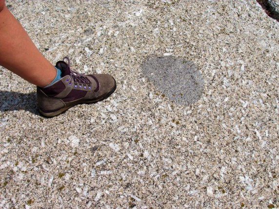
Xenolith (dark spherical rock fragment) in Pennant point granites. The white, somewhat aligned flecks are aluminum-rich feldspars that give the granite its distinctive light (‘leuco’) colour.
The South Mountain Batholith became exposed to the surface the several million years ago, so that it became subjected to the forces of Pleistocene glaciations. Several directions of ice movements are detected along these shores, but, in general, the ice moved away from ice domes situated over major land masses towards the sea (which stood on average 100 m below that of today). The ice caps, a kilometer or more in thickness, had tremendous erosive power. They smoothed the rock surface, and rock fragments that scraped the rock at the base of the ice cap left long grooves in the granite, indicative of the direction of ice flow.

Granite outcrop at Pennant Point with glacial grooves (called ‘striae’) indicating the direction of the ice flow (look close: they are parallel to the added red line). The ice cap both smoothed and scratched the rock surface
When the ice melted away, many of rocks that were incorporated in the ice flows, were left stranded. These are called ‘erratics’. While most erratics in this area consist of the same granite as the outcrop, erratics may have traveled hundreds of kilometers, thus leaving important clues for reconstructing the origin and direction of Pleistocene ice flows.

Glacially smoothed granite surface with glacial erratics (same granites) at Pennant Point.

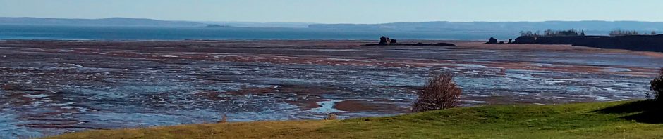
Along the eastern side of the Pennant Peninsula
Then came the people
Sadly but not surprisingly, we found an immense amount of sea-borne trash on our hike. Other than the usual macerated lobster traps, buoys, gasoline cans and fishing lines, the most impressive piece was a massive 30ft piece of a wharf that rested at the red star at the top of the lake in the Google Earth image, nearly 100 m from the water edge. There was a lot of other trash around the perimeter of the little lake in the image (a.o. a Canadian Coast Guard buoy that was spilling styrofoam mini-pellets), but this was definitely the biggest piece. The assembly of trash and their location clearly shows that this lake and its boulder-rubble seaward edge is a classic storm washover feature, created by repeated battering and overwash from massive storms and hurricanes. Somewhere is a community with a big repair bill. Everywhere are all of us, “planet earth astronauts” (thank you Chris Hadfield) with an even bigger repair bill: that of the maintenance and repair of our fragile and only home.


30 ft piece of a wharf, resting at the red star in the Google Earth image. Red dashed line indicates washover feature. Other washovers can be seen on the left ![]() side of the point. Red star is nearly 100 m from the sea
side of the point. Red star is nearly 100 m from the sea
References
Clarke, D.B. and S. Carruzzo, 2007, Assimilation of country-rock ilmenite and rutile in the South Mountain Batholith, Nova Scotia, Canada. The Canadian Mineralogist, v. 45, pp. 31-42.
MacDonald, M.A., 2001, Geology of the South Mountain Batholith, southwestern Nova Scotia. Nova Scotia Department of Natural Resources, Open File Report ME 2001-2


Reblogged this on Explosive Earth and commented:
Great post from Earth, Science and Society