The preamble to this review series is here. All reviews in this series are categorized as “Canadian Earth Science for @PMHarper” (see right hand column).
=====
Turner, E.C., 2009, Mesoproterozoic carbonate systems in the Borden Basin, Nunavut. Canadian Journal of Earth Sciences, v. 46, p. 915-938

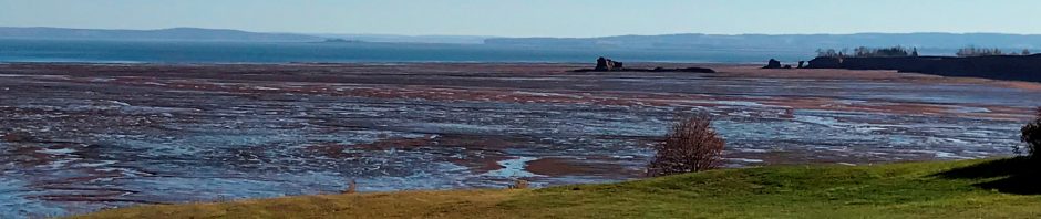
Figure 1. Borden Peninsula near Arctic Bay. Image Source: Google Earth
Canada has immense mineral resources. The Geological Survey of Canada (GSC), a branch of the Earth Sciences Division of Natural Resources Canada is responsible for most basic geologic mapping north of 60oN (and a lot more); the Provincial and Territorial Geological Surveys do all other basic geologic mapping (plus a lot more).
Why do we need basic geologic mapping? Because a geologic map (analog/digital) is the basis for justifying investments in developing and managing a territory as well as the basis for further fundamental geological research. Whether it is resource development, hazard mitigation, groundwater management, or any other human intervention in the land, a basic understanding of underlying geology is a necessary start.
This article is an outflow of a “North of 60” geologic mapping project, namely that of the Borden Peninsula of Baffin Island, Nunavut. The peninsula sits at 72-73o N and is essentially uninhabited, except for the small community of Arctic Bay.
The area under investigation is about 250 x 50 km large. Is it a priority to do geologic mapping all the way up there? Yes, because this area is rich in mineral resources: there is, or rather was, a Lead-Zinc mine: the Nanisivik mine. It operated from 1976 to 2002. The mine site has been cleaned up since 2007 and the community of Arctic Bay has been left with a mixed blessing (see further ‘Additional information’ below).
Finding natural resources is like a sophisticated treasure hunt: the first findings are the ones that stare you in the face. When those run out, you start scratching your head: would there be more? A better understanding of the different rock formations and their relations is then required. That’s what the original goal of this project was: improving understanding of the geological formations that host these ores.
But if you understand this ore-setting better, you can also improve your understanding of other Lead-Zinc ore bodies in comparable geologic settings elsewhere in the world (e.g. in Nova Scotia): studying comparable geologic sites increases the understanding of comparable (not: the same) mineral occurrences.
The rocks of the Borden Basin are about 1.2 billion (1,200,000,000) years old and the formations under investigation consist largely of limestone and dolostone. Limestone is Calcium Carbonate (CaCO3) and dolostone or dolomite is Calcium Magnesium Carbonate (CaMg(CO3)2).
Limestone can form in inorganically and organically. In the inorganic process, seawater evaporates in warm latitudes and shallow seas. As it evaporates, supersaturated carbonate precipitates around tiny grains of sand and the result are extensive and thick beaches and lagoons made up of ooids. This process has been going on for billions of years and is still going on today: most of the beaches on the Bahamas are made up of ooids.
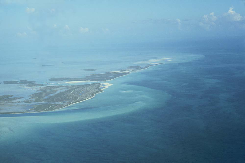
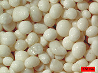
Figure 2. Ooids. Left: Joulter’s Cay, Bahamas – an extensive, thick carbonate platform made up largely of ooids. Right: ooids under the microscope. Each ooid is less than 2 mm in diameter.
But most marine limestone is formed as a result of biological processes: organisms build calcareous (CaCO3) external skeletons (shells, reef structures) by extracting dissolved carbonate from sea water. However: skeleton-building organisms did not exist 1.2 billion years ago – it would take another 600 million years for the first ones to evolve.
Some algae and bacteria also secrete carbonate, mostly in thin filaments that build on top of each other and look like tree rings when you see them in cross section. Algae and bacteria were pretty much the only living organisms back 1.2 billion years ago and some of these algae still exist today: they are called stromatolites and the most famous place where they occur is Shark Bay in western Australia, a UNESCO World Heritage site.

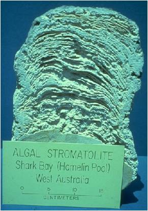

Figure 3: Stromatolites ‘algal mounds’. Left: people looking at stromatolite mounds in Shark Bay, western Australia. Middle: Shark Bay stromatolite cut in half. Right: 1 billion year old stromatolite, looking the same as modern-day Shark Bay stromatolite.
Earth was very different 1.2 billion years ago. Atmospheric oxygen was about 1% of today’s and the sun only had about 3/4 of its current strength. While scientists are still debating the details of the atmospheric and oceanic conditions of this era, there appears to be enough evidence to suggest that earth was relatively warm and could support lots of primitive life. Plate tectonics, the process of mid-ocean spreading, subduction and continent motion, was working too.

Figure 4. Left: Geologic Map of the Borden Peninsula (Turner, 2004a). Right: Google Earth image at approximately the same scale.
Let’s look at the geologic map of the Borden Peninsula and put a Google Earth image next to it (Figure 4). Stunning! The geologic map displays rock formations oriented in a NW-SE direction. The Google Earth image shows clear NW-SE lineaments. So yes: the structure (a geologic basin) in which these limestones precipitated 1.2 billion years ago is recognizable to the naked eye today.
The lineaments on the satellite image are indicative of the structure, i.e. the basin in which these limestones were laid down. The structure (faults) tell us that the basin was formed in a process called rifting. Because we know that plate tectonics was working then as it is today, you should imagine the environment being somewhat comparable to the Red Sea: a narrow seaway at a relatively low latitude (warm!). The Red Sea too is part of a (rather complex) rift system, lying at the upper extent of the East African Rift.
It gets better (what did we ever do before Google Earth?). Let’s fly to the area of the red arrow on the Google Earth image in figure 1 and drop our imaginary plane down:
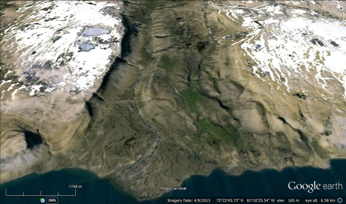
Figure 4. Google Earth close-up image of the area at the red arrow in Figure 1. The lineaments on the satellite image represent a distinct valley through which a river runs, building a small delta into Milne Inlet.
There you go: the relief we see today on far away Borden Peninsula reflects the remainder of the relief of 1.2 billion years ago. Pretty amazing.
During rifting, heat rises upwards from the earth’s mantle, forcing the earth’s crust to thin and sag, forming a rift basin. The floor and sides of the basin continue to experience high heat flow until rifting stops. When rifting stops, the basin stops opening and subsiding because heat flow was the engine for the rifting process.
The rising heat brings magmas closer to the earth surface as well. Such magmas contain all kinds of trace elements, including metals. In the Borden Basin, cracks (faults) in the rifting basin allowed for focused release of hot chemically charged plumes, which precipitated as mounds, surrounded by some filament-building algae. These mounds are where the Lead-Zinc complex is found today.
In short: in the shallow areas of this basin, extensive Bahama-bank like ooid shoals and beaches kept piling up as the basin floor subsided; in the deeper parts of the basin, concentrated heat flow caused mounds to build-up, incorporating metals and other trace elements.
So the immediate relevance of this mapping project was to locate and understand the ore-hosting formations. As a result, earlier named geologic rock units got renamed. Three new formation names were introduced and they all have Inuktituk names: The Ikparjuk (meaning ‘pocket’) Formation contains the isolated carbonate mounds that are the host of the Lead-Zinc complex. The other new Formation names are the Nanisivik (meaning ‘place where people find things’) and Angmaat (meaning ‘flints’) Formations.
The results of this project contributed to a better understanding of the Nanisevik Lead-Zinc ore body. In addition, much was learned about the ocean-atmosphere conditions during a very old and poorly known period in earth history: a practical question led to much fundamental knowledge that can be applied to other, comparable, geological problems.
This was an important paper: it became the most cited 2009 paper in the Canadian Journal of Earth Sciences.
Additional information on the Nanisivik mine:
The Nanisivik mine produced Lead (Pb) and Zinc (Zn).
- Lead: The global demand for Lead is still rising, despite the fact that the applications for toxic Lead are decreasing thanks to invention of substitutes. There is still significant demand for Lead in Lead-acid batteries. Read more about Lead here.
- Zinc: the following is from the USGS minerals database: about 3/4 of all zinc used globally is applied to galvanizing metal. The remaining 1/4 is consumed as zinc compounds mainly by rubber, chemical, paint, and agricultural industries. Zinc is also a necessary element for proper growth and development of humans, animals, and plants; it is the second most common trace metal, after iron, naturally found in the human body.
The Nanisivik mine had its own Arctic Port, which the Canadian Department of National Defence (DND) intended to upgrade and use as an Arctic fueling port. Significant ground instabilities appear to wreak havoc with those plans.
A 2002 report on the mixed-success legacy of the Nanisivik mine on the community of Arctic Bay can be downloaded here.
References
Hahn, K and E.C. Turner, 2013, Mesoproterozoic deep-water carbonate mound lithofacies, Borden Basin, Nunavut. Geological Survey of Canada, Current Research, 2013-11, 17 p.
Turner, E.C. 2003a. New contributions to the stratigraphy of the Mesoproterozoic Society Cliffs Formation, northern Baffin Island, Nunavut. In Current research. Geological Survey of Canada, 2003-B2.
Turner, E.C. 2003b. Lead-zinc showings associated with debrites shed from synsedimentary faults, Mesoproterozoic Society Cliffs Formation, northern Baffin Island, Nunavut. In Current research. Geological Survey of Canada, 2003-B2.
Turner, E.C. 2004a. Origin of basinal carbonate laminites of the Mesoproterozoic Society Cliffs formation (Borden Basin, Nunavut), and implications for base-metal mineralisation. In Current research. Geological Survey of Canada, 2004-B2.
Turner, E.C. 2004b. Stratigraphy of the Mesoproterozoic Society Cliffs Formation (Borden Basin, Nunavut): correlation between northwestern and southeastern areas of the Milne Inlet Graben. In Current research. Geological Survey of Canada, 2004-B3.
Turner, E.C. 2004c. Kilometre-scale carbonate mounds in basinal strata: implications for base-metal mineralisation in the Mesoproterozoic Arctic Bay and Society Cliffs formations, Borden Basin, Nunavut. In Current research. Geological Survey of Canada, 2004-B4.
Turner, E.C., and Long, D.G.F. 2008. Basin architecture and syndepositional fault activity during deposition of the Neoproterozoic Mackenzie Mountains Supergroup, N.WT., Canada. Canadian Journal of Earth Sciences 45: 1159–1184.

