I recently spent a few days in the Sine-Saloum delta in Senegal. You have likely never heard of this delta and that’s not surprising. It’s small and not very well researched. As a delta sedimentologist, I was mesmerized by the little bit that I discovered on location and by reading up on it later. Like all deltas, people have interfered with it for a long time, thought not at the extent of e.g. the Rhine or Mississippi Deltas, but still – it’s impossible to write about it without mentioning human activity.
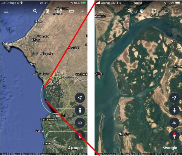
Western Senegal and the Sine Saloum Delta. The distance from the city of Kaolack to the coast is ca. 100 km. We explored the delta from the small fishing town of Djiffer
The delta is formed by two rivers, the Sine and the Saloum. This area, at roughly 13degN, is on the southern edge of the Sahel region, which has experienced increased and devastating droughts since 1970s, as as result of which the flow of the rivers is so small that this has become is a Reverse Estuary: the salinity of the water increases in a landward direction. Precipitation is controlled by the West African Monsoon, which has a regional variability across Senegal. In the area of the Sine-Saloum Delta, annual rainfall averages between 850-1000 mm, almost all of it falling between June and October (Raj et al., 2019). The tide range at the coast is semi-diurnal with a maximum range of ca. 1.5 m.
This area is part of the Senegal Basin, the sedimentary wedge here is more than 4,000 m thick. I have not been able to find what the specific geologic basis for this modern, relatively small drainage basin is. The much larger Senegal River basin is hundreds of kilometers to the North and the sizeable Gambia River basin ca 100 km to the South. Many of the big rivers on this side of the continent are situated along Precambrian basement structures, but again, I haven’t found out the reason of the Sine-Saloum topographic low.
Part of the delta coastline was was declared a Ramsar International Wetland in 1976 (https://www.ramsar.org/wetland/senegal). It deserves this recognition because it is an important wintering habitat for (northern) European migratory birds. Because we were there in February, we saw storks, spoonbills and many European wading and meadow birds such as oyster catchers and curlews.
The area received recognition as a UNESCO World Heritage Site in 2011 (https://whc.unesco.org/en/list/1359/). The WH designation is earned for its universal value as a cultural landscape, namely more than 200 magnificent shell middens, some hundreds of meters long and several meters high. Twenty-eight of the mounds have burial sites with remarkable artefacts. Prehistoric people lived here since at least 5,000 years BP. UNESCO: “The middens are important for improving the understanding of historic cultures and testify to the history of human settlement along the coast of West Africa”. The historic middens consist mostly of the West African blood cockle (Anadare senilis). An analysis of the growth patterns and monthly resolved δ18O profiles of some of these bivalves in one of the prehistoric middens suggests that the West African Monsoon (WAM) has shifted over recent times. The time interval studied, 460-1090 AD, was consistently wetter than it has been in the 20th century, possibly because of a shift in the Atlantic Meridional Overturning Circulation (Gulf Stream)
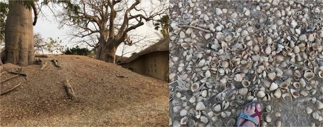
One of the many middens, almost entirely consisting of shells of the bivalve Anadare senilis. This midden is on the grounds of a guest facility.
The conservation efforts have led to a bit of tourism and hence some income for the local population, the Sereer people. This group fled from ca. 300 km further north along the Senegal River to the Sine Saloum delta ca. 800 years ago. They fled the islamisation of the region and remain mostly Catholic to this day. They are therefore unrelated to the prehistoric people who built the middens.
The Sereer people do not eat blood cockles, they eat only the swamp oyster (Crassostrea gasar), which grows massively on mangrove roots in the delta. Only women harvest the oysters. They live for several months in makeshift camps in the delta. They harvest the oysters at low tide, cook, shuck and dry them. Then – so we were told – they are packed and sold. Oysters are highly prized so the women have a parallel (cash) economy. The oyster harvesting also results in middens, and they too are big, as we witnessed (see below).
The men fish offshore and in the mouth of the estuary in their big, colourful hand-built pirogues. The fishing stocks have declined and it’s hard to make a living. The fish (kettlefish and sole, among others) is exported in cooled trucks directly from the dock in Djiffer and shipped to Europe. There is sardine fishery too, but this is done only by Guineans, not by the Sereer. The sardines are cleaned and dried and exported.
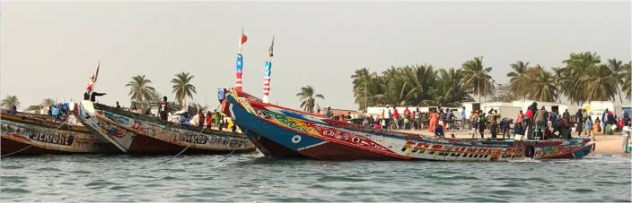 Pirogues in Djiffer
We boarded our pirogue in Djiffer, now the southernmost point on this long sandspit (the longshore current flows from North to South, obviously), but it hasn’t been the southernmost tip for long, because the spit was breached by a storm in 1987 and the breach has never healed. The Ramsar Wetland is the uninhabited spit remnant south of the river mouth.
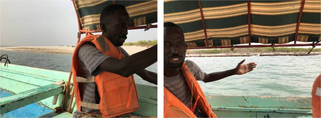
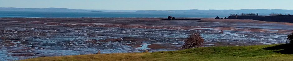
Two pictures taken just South of Djiffer. River mouth is to the left in the LH picture. Active sediment reworking takes place. In the RH picture our guide (a local Sereer man who was very knowledgeable and spoke both French and English as well besides his native language Wolof) points to the remains of mangrove roots which were cut down by local people here until a few years ago.
There was much wave breaking at the river mouth, so it’s very shallow – a dynamic sandy environment. After the spit breached, some shore parallel sediment reworking took place along the inner part of the delta. Mangroves were cut cut down for firewood until a few years ago. As our guide said “yes, they used to cut mangroves, they had to cook food and there was no propane, what choice did they have?” Now that propane is available again, the mangroves are beginning to grow back, providing much needed protection against erosion. They are also actively planted and are regrowing well.
 Swamp oysters (Crassostrea gasar) growing on Mangrove roots along the tidal channels in the delta.
We stopped at one of the modern-day Oyster middens. It was late morning and the women were asleep in their hut and we didn’t disturb them. This modern oyster day midden is enormous, it’s even visible on Google Earth!
 Clockwise from top left: Modern Oyster midden that we visited visible on Google Earth; an impression of the relief of this modern midden; unvegetated area landward of the midden; processed oysters drying in the temporary camp of the women.
Behind the oyster midden, also visible on the satellite image are bare areas. My guess is that these flood only during Spring tide and that the soil has become so saline that nothing else grows there the rest of the time. But I’ll happily be corrected.
Artisanal salt mining
Small scale salt mining has massively changed the supratidal flat areas. It looks like this industry involves exclusively local, informal labour (including children), the salt is bagged and shipped off by large trucks.
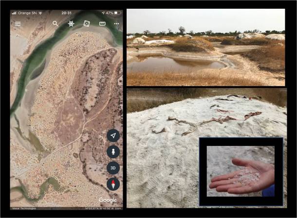
Artisanal salt mining a few kilometers NE of Djiffer. Left hand panel: Google Earth image showing the supratidal flats dotted with hand-dug salt pans. Top Right: salt pans are ca 5 meters across. The humps in between are mounds of salt, usually covered with tarps, waiting until the salt can be bagged and exported. Lower Right: uncovered salt mound with some beautiful cubic NaCl on my hand.
Fantasizing about the sedimentology here, I was trying to come up with a schematic sequence for this delta and realized I don’t quite have enough information to sketch one. Its main components are fine sand, mud, evaporites and colonies of Oysters and Cockles. I’d love to find out more. And I’d love to return.
References
Azzoug, M., et al., 2012, Positive precipitation-evaporation budget from AD 460-1090 in the Saloum Delta (Senegal), indicated by mollusk oxygen isotopes. Global and Planetary Change, v. 98-99, p. 54-62.
Azzoug, M., M. Carre and A. Schauer, 2012, Reconstructing the duration of the West African Monsoon season from growth patterns and isotopic signals of shells of Anadara senilis (Saloum Delta, Senegal), Paleogeography, Paleoclimatology, Paleoecology, v. 346-347, p. 145-152.
Ecoutin, J.M., M. Simier, J.J. Albaret, R. Lae, L. Tito de Morais, 2010, Changes over a decade in fish assemblages exposed to both environmental and fishing constraints in the Sine Saloum estuary (Senegal). Estuarine, coastal and shelf science, v. 87, no. 2, p. 284-292.
Hardy, K., A. Camara, R. Pique, E. Dioh, M. Gueye, H.D. Diadhiou, M. Faye, M. Carre, 2016, Shell fishing and shell midden construction in the Saloum Delta, Senegal. J. of Anthropological Archaeology, v. 41, p. 19-32.
Raj, J., Hamza Kunhu Bangalath, G. Stenchikov, 2019, West African Monsoon: current state and future projections in a high resolution AGCM. Climate Dynamics, v. 52, p. 6441-6461. Open Access: https://link.springer.com/article/10.1007/s00382-018-4522-7
Vidy, G., 2000, Estuarine and mangrove systems and the nursery concept: which is which? The case of the Sine Saloum system (Senegal). Wetlands Ecology and Management, v. 8, p. 37-51.


Thanks, this was really interesting as a follow-up to our family’s visit to the delta! Just a note – if your guide was Sereer (per photo caption), likely his native language is not Wolof but Sereer. He surely also speaks Wolof, in addition to the French and English you mention!
Thank you! I’m glad you found this post helpful and I’ll make that correction.