The pre-amble to this series of reviews is here
Froese, E.G., Zazula, G.D., Westgate, J.A., Preece, S.J., Sanborn, P.T., Reyes, A.V., Pearce, N.J.G., 2009, The Klondike goldfields and Pleistocene environments of Beringia. GSA Today, v. 19, no. 8, p. 4-10.
We live in a time that is characterized by the coming and going of Ice Ages. Many people think of the Ice Ages as something of the past, but our current Holocene period (roughly the last 10,000 years) is just the latest warm interval in 2 million year period of glacials and interglacials (whether humanity is warming the planet to the extent that we won’t be able to return to an ice age at some point, is not the subject of this blog post).
For this post, I am only concerned with northern hemisphere ice ages. During such periods, Arctic ice caps swelled, crawled southward and at some point began to retreat again. When ice caps reached their southernmost extent, we talk about a ‘glacial maximum’. The most recent glacial maximum, called the ‘last glacial maximum’ (LGM), lasted roughly from about 26,000 to 20,000 years ago.
While ice caps can overrun all kinds of topography and generally cover a continental area indiscriminantly, it’s not unusual for certain pockets to remain free of ice, usually because it’s too dry, as in today’s Dry Valleys in Antarctica. During the LGM, and probably during earlier glacial maxima as well, parts of Yukon and Alaska were ice-free, as shown in these illustrations.
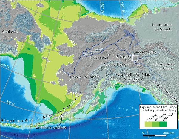
Alaska and Yukon during the Last Glacial Maximum (26,000-20,000 years ago). Global Sea Level stood ca. 120 m lower than today. The green colours show regions that are currently under water but were land during the LGM, thus forming a continuous land area between NW North America and NE Asia (the ‘Bering Land Bridge’). The pinkish area is now and was then land and it was largely unglaciated, except for local uplands. Figure 1 from the discussed paper. Original image from Ehlers and Gibbard, 2004.
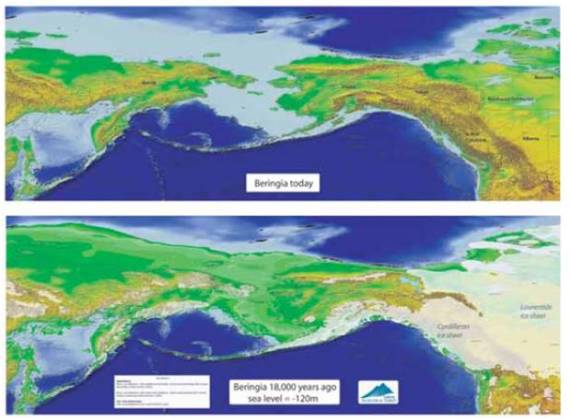
The entire area is known as Beringia, a 3,000 km wide region. Figure from Yukon Gov’t website
This ice-free region was a freeway, an interstate, a favourite hiking trail for every living being that couldn’t fly or swim and had the urge to travel east to North America, or West to Siberia. Included in this crowd were the ancestors of indigenous Americans (they likely also paddled, but that’s a different story).
Beringia was likely also largely ice free during the waxing and waning of earlier continental ice sheets, maybe as far back as 2 million years ago. So each time the continental ice caps covered the region, this area remained ice-free, a perfectly delineated refuge for plant and animal species traveling, living and dying through the cold spell. And the absolute most special thing of all is that it is possible to acquire precise dates for when various ecosystems existed thanks to the presence of a number of active volcanoes in the Aleutians. Volcanoes blanket large areas with ash. The ash of each volcano has fairly unique composition so that we can distinguish between different ash layers. Also, volcanic ash contains unstable isotopes that enable dating them precisely using radiometric dating methods.
What does this have to do with gold mining?
Miners dig. They create holes in the ground, sometimes very large holes and in this way they expose underlying rock and/or sediment. Ever since the first Klondike Gold Rush in the late 1990’s, the area has been a treasure trove of Quaternary-age fossils, exposed by the work of gold miners, followed on their heels by paleontologists from all over the world. Much of the gold is sourced in a mountain called the King Solomon’s Dome, so many of the gold mines are located in the banks of creeks running off the dome where the gold that eroded off the mountain became part of the sediment deposited around it. The climate had a big control in how much sediment was produced from mountain erosion. During ice ages, the sediment became frozen solid and much of it remains frozen today, sometimes mixed in with wind-blown dust from those times and also mixed in with volcanic ash. This lovely mixture (gravel, ice, silt, and ash) is known as ‘muck’. This muck is “Beringia’s Ice Age Freezer”. To this day, the best muck sites are on north and east-facing slopes or in narrow valleys, i.e. areas that receive the least sun and are thus also covered by insulating soils and vegetation.

Yukon’s King Solomon’s Dome, showing radial drainage patterns. Many of the Klondike gold mines exist along these creeks and rivers.
Interestingly, these valley sides and bottoms were better drained during glacial times thanks to the presence of burrowing ground squirrels which no longer live there. They aerated the soil, so that it could support grasses and herbs, the favourite food for large herbivores such as mammoths, horses and bison (also found as stomach remains in these fossils). Today’s interglacial (warm period) vegetation would not support those grazers!
==
What a fascinating story, made possible by blending the knowledge and experience of so many different experts: a diversity of paleontologists, soil scientists, (paleo)-ecologists, geologists, miners and historians (and forgive me if I forget someone). This is one of those role-model-stories that goes to show that our different scientific fields are not isolated from each other, that innovation takes place by bringing gaps between well-established fields.
For knowledge to truly develop and progress, it must be able to both deepen and widen. Deepening through specialization (how do you tell one volcanic ash layer apart from another, for example) and widening through connecting specialized findings with each other (e.g. ground squirrel burrows and fossilized stomach content). Most of these knowledge cooperations aren’t planned at the onset, i.e. decades ago when earlier generation scientists established the original knowledge base in their field.
This kind of dynamic is always difficult to explain to the general public (including politicians). Many people continue to think that scientists just dally along, meandering happily along their hobby paths without feeling an ounce of accountability towards the tax payer (usually their sponsor). Such people would like to see more innovation, more direct results. Problem is, that’s very hard to enforce and efforts to control and direct have a serious risk of impoverishing of the knowledge base.
While this story may seem to be just another lovely hobby story (what is really the societal relevance of extinct mammoths, right?), this research does improve our understanding of the intricate smaller-scale details of climate change and that in turn may help improve predictions about what’s awaiting us in the near future.
In addition, this story forms part of the rich cultural heritage of Beringia-Klondike and it may some day become formally recognized internationally.
External links
The popular version of this journal article is a downloadable pdf on the website of the Government of Yukon
Yukon Beringia Intepretive Centre
US National Park Service Klondike Goldrush website
Wikipedia Klondike Gold Rush page
Travel Yukon page on Klondike Gold Rush
Canadian Encyclopedia entry on Klondike Gold Rush

