The preamble to this review series is here.
Gillis, K.M., J.E. Snow, A. Klaus, N. Abe, A.B. Adriao, N. Akizawa, G. Ceuleneer, M.J. Cheadle, K. Faak, T.J. Falloon, S.A. Friedman, M. Godard, G. Guerin, Y. Harigane, A.J. Horst, T. Hoshide, B. Ildefonse, M.M. Jean, B.E. John, J. Koepke, S. Machi, J. Maeda, N.E. Marks, A.M. McCaig, R. Meyer, A. Morris, T. Nozaka, M. Python, A. Saha, R. Wintsch, 2014, Primitive layered gabbros from fast-spreading lower oceanic crust. Nature, v. 505, p. 204-208
The earth has just two types of crust: continental crust and oceanic crust. Continental crust forms most of the continents. Oceanic crust forms most of the oceans. The earth is like a cracked sphere consisting of a dozen or so pieces of moving oceanic and continental crust. The pieces are called plates and their dynamical interaction is called plate tectonics (from ancient Greek, meaning “pertaining to construction”). We have known about plate tectonics for just 50 years. Plate Tectonics explains everything about the earth’s crust, but while we know this to be the case, it doesn’t mean we have found every explanation for every observation as yet.
Plates move around today and have been doing so for close to 4 billion years (the earth is a little over 5 billion years old). There are only three possible plate movements: plates can move away from each other (spreading), they can collide, and they can slide alongside each other. Plates spread at (mid)ocean ridges where magma wells up and accretes on two sides of a zipper line. This process creates oceanic crust. The best known example of spreading is the Atlantic Ocean that has a beautiful zipper line in the center from where the ocean grows at about 2-3 cm per year (more or less the rate at which your finger nails grow) increasing the distance between the continents. Spreading usually isn’t accompanied by very volatile earthquakes and volcanic eruptions.
Because the earth as a sphere doesn’t get any bigger or smaller, the result of spreading (which increases plate size) is that shrinking must take place elsewhere. Shrinking goes through collision and the most famous collision zones are along the Pacific margin where oceanic crust disappears below continental crust, giving us the ‘ring of fire’ with lots of earthquakes and volcanoes. The most famous area where plates slide alongside each other is along the San Andreas fault in California and along the Great Anatolia fault in Turkey.
But even the Pacific Ocean, which is shrinking as we speak, still has are spreading ridges. Consider the figure below.
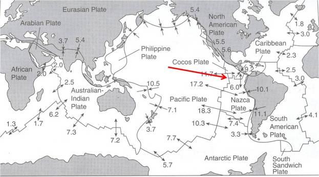
Map of the earth’s plates, and their rate of motion in cm/year. The higher the number, the faster the motion. Spreading is shown as opposite facing arrows, collision as arrows pointing to each other and and sliding as half arrows in opposite direction. Note that there is pretty consistent spreading along the length of the Atlantic Ocean and a combination of spreading and collision (subduction) at widely varying rates along and in the Pacific Ocean. The red arrow points to the Hess Deep, the area where the authors collected their samples. Figure 4.1 from Moores and Twiss (1995)
Because these processes have gone on for such a long time, many previously existing plates have disappeared over the eons, they are consumed into more recent plates through collision and sliding processes. How do we know? Because we find pieces of oceanic crust (with a distinct, unique combination of minerals) incorporated in continental rocks. Such pieces of oceanic-crust-now-on-land are called ophiolites and they are studied intensely as they give us a unique window into understanding the history of the earth.
The figure below shows the locations of ophiolites in the world. The most famous one in Canada is right in Gros Morne National Park and this was in fact one of the main reasons for designating the national park as well as getting a UNESCO World Heritage status. The Bay of Islands ophiolite is an important piece of Canadian geoheritage.

The research project that this article presents was carried out as ‘Legs 345’ of the Integrated Ocean Drilling Program using the drill ship JOIDES Resolution. JOIDES stands for Joint Oceanographic Institutions for Deep Earth Sampling, the largest international cooperative earth science program in the world which has been going on since 1968.
Leg 345 sampled a fast spreading centre in the eastern Pacific, known as the “Hess Deep”. This project was a successor to Leg 147, which sampled the same area in 1993. Bear in mind that the average depth of the ocean here is 4 km.
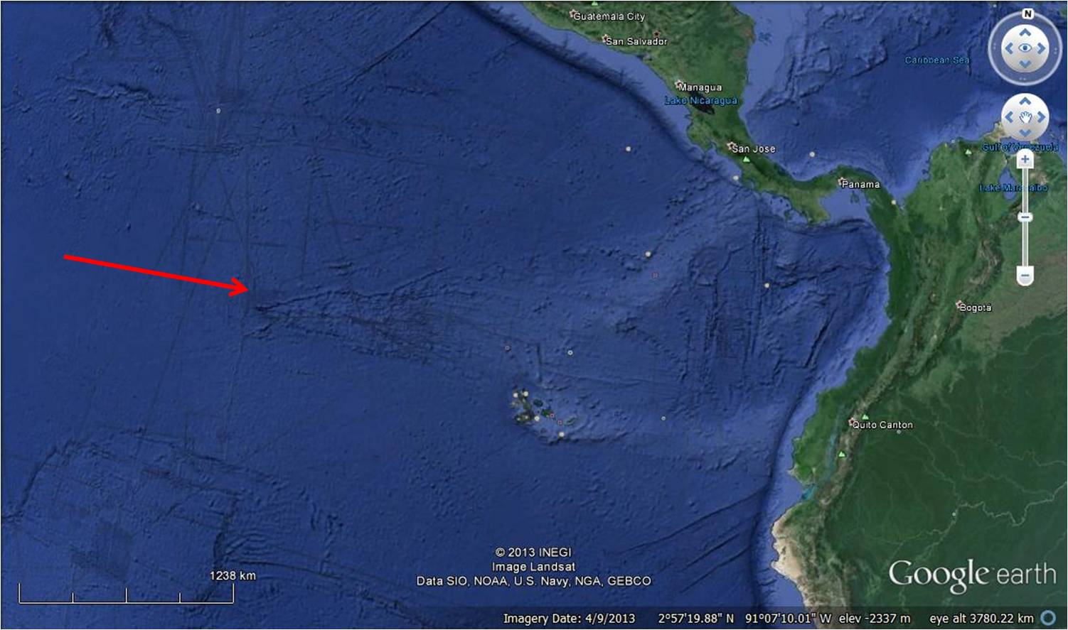
Location of the “Hess Deep” spreading centre in the eastern equatorial Pacific Ocean.
The expedition had two chief scientists: Dr. Jonathan Snow of the University of Houston and Dr. Kathryn Gillis of the University of Victoria. Kathryn Gillis also led the earlier Leg to the same area in 1993.

Expedition co-leaders Jonathan Snow (left), Kathryn Gillis (centre) and core curator Chad Broyles (right) aboard the JOIDES Resolution during the expedition. Image source here
Why drill here? To see if they could find the type of oceanic crust that was thought to be typical for fast spreading centres. Why is that important? Because three-quarters of the world’s oceanic crust formed at fast-spreading ridges. Why should we care about that? Because of two reasons:
- for the intrinsic value of pure discovery. In this case, discovery that will improve our understanding of the history of the earth.
- because many of the earth’s important and valuable minerals occur in rocks that were once part of the oceanic crust. If we can better understand how the oceanic crust formed, we’ll improve our understanding of mineral occurrences.
Bonanza was granted the researchers. The drill ship retrieved oceanic crust with a layered appearance and a unique mineral composition that tells us much about the properties of the molten lower crust, how it differentiates as it solidifies and what this means for interpreting plate movements.

This piece of core is about 5 cm across and about 12 cm long. It shows alternating light and dark layers of gabbroic rock. These rocks – the first of their kind to be recovered – help confirm a long-standing belief that the gabbroic rocks in the lowermost part of the oceanic crust are layered. These layers are defined by the relative abundance of the minerals olivine, clinopyroxene, and plagioclase; differences in the mineral content gives each layer its light and dark appearance. Image courtesy Kathryn Gillis – figure from the article, accessible online (with this figure caption) here.
It’s a big achievement to be an IODP (co)-chief scientist. Kathryn Gillis is an outstanding geoscientist and is featured as one of the world’s leading women oceanographers here.
===
The IODP is an astonishingly productive program, initiated in 1968 by the United States only five years after the theory of plate tectonics was formulated. The only individual countries that are full members are the United States, Japan, Korea, Australia/New Zealand, and China. The European Union is a full member too. Canada was a full member, but withdrew some years ago. Canada now operates under the auspices of the European Union membership (see www.iodp.ca for more details). This is embarrassing because Canada, the world’s second largest country bordering three oceans, has as much voice in IODP as any small European member country. Which is not a full voice, that’s for the full members. Despite the remarkable achievements of Canadian scientists, we don’t really count in this international arena.
 The JOIDES Resolution drill ship
Reference
Moores, E.M. and R.J. Twiss, 1995, Tectonics. W.H. Freeman and Co., New York, 415 p.

