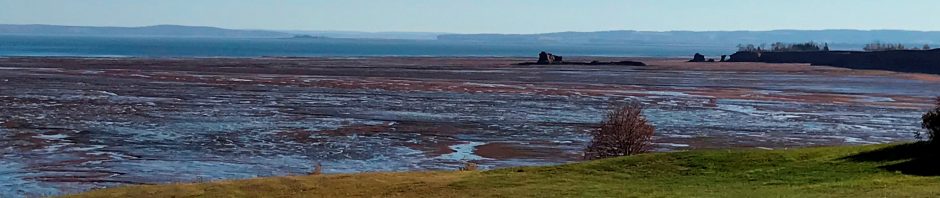

Figure 1. River Eem at town of Eemdijk (to the right), Netherlands. The view is to the North. Eem floodplain (ca. 1 m below MSL) to the left. Location of photo: 52o15’17.65″N, 5019’38.42″E
The Eemian interglacial warm period is known as the Sangamonian in North America and as Isotope stage 5e in paleoceanographic and climatic circles. It followed the Saale/ Illinoian glacial period.
The Eemian lasted from ca. 130,000 – 115,000 years ago and was followed by the most recent glacial period (Weichselian/Wisconsinan), which lasted until about 11,000 years ago when the current warm period, the Holocene began.
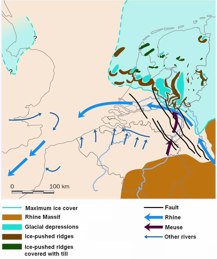
Figure 2. ‘Maximum ice cover’ is the maximum ice cover of the Saale/Illinoian glacial period. The ‘Glacial Depressions’ shown on this figure are Saalian in age and were inundated by the subsequent Eemian Sea (see figure 3). The Weichsel/Wisonsinan ice cap didn’t reach as far South as those of the Saale glacial. ‘Ice-pushed ridges’ are moraines. The ‘faults’ are part of the tectonic fabric of the failed rift system of the Rhine/North Sea. Figure from Vlaar, 2007

Figure 3. Maximum extent of the Eemian sea. Figure from Vlaar, 2007
The Eemian interglacial was on average about 2degC warmer than the Holocene has been so far. There have been other periods in Earth history that have been lots warmer, but the Eemian is so young that it is therefore especially relevant to study. Why? Because continental configurations were the same as today, so that it becomes possible to model and understand the oceanographic and atmospheric conditions of this period. A better understanding of the Eemian is essential for enabling better models for future global warming. Lots of scientists research aspects of the Eemian interglacial. Here I only mention the NEEM project here (www.neem.dk). NEEM stands for North Greenland Eemian Ice Drilling, an international ice core research project aimed at retrieving an ice core from North-West Greenland (camp position 77.45°N 51.06°W) reaching back through the previous interglacial, the Eemian.
Few people know that the Eemian is named after the River Eem in the Netherlands. Full disclosure: I grew up in a town on the River Eem (not the one in the picture) and spent my high school years rowing skiffs, doubles and 4-s on the river. My first job was a paper route which required bicycling many long hours along the river, delivering the local rag to the dispersed farms. The graphic artist M.C. Escher lived in that area too. One of his better known images is ‘Day and Night’ which might very well have been inspired by the landscape along the Eem river
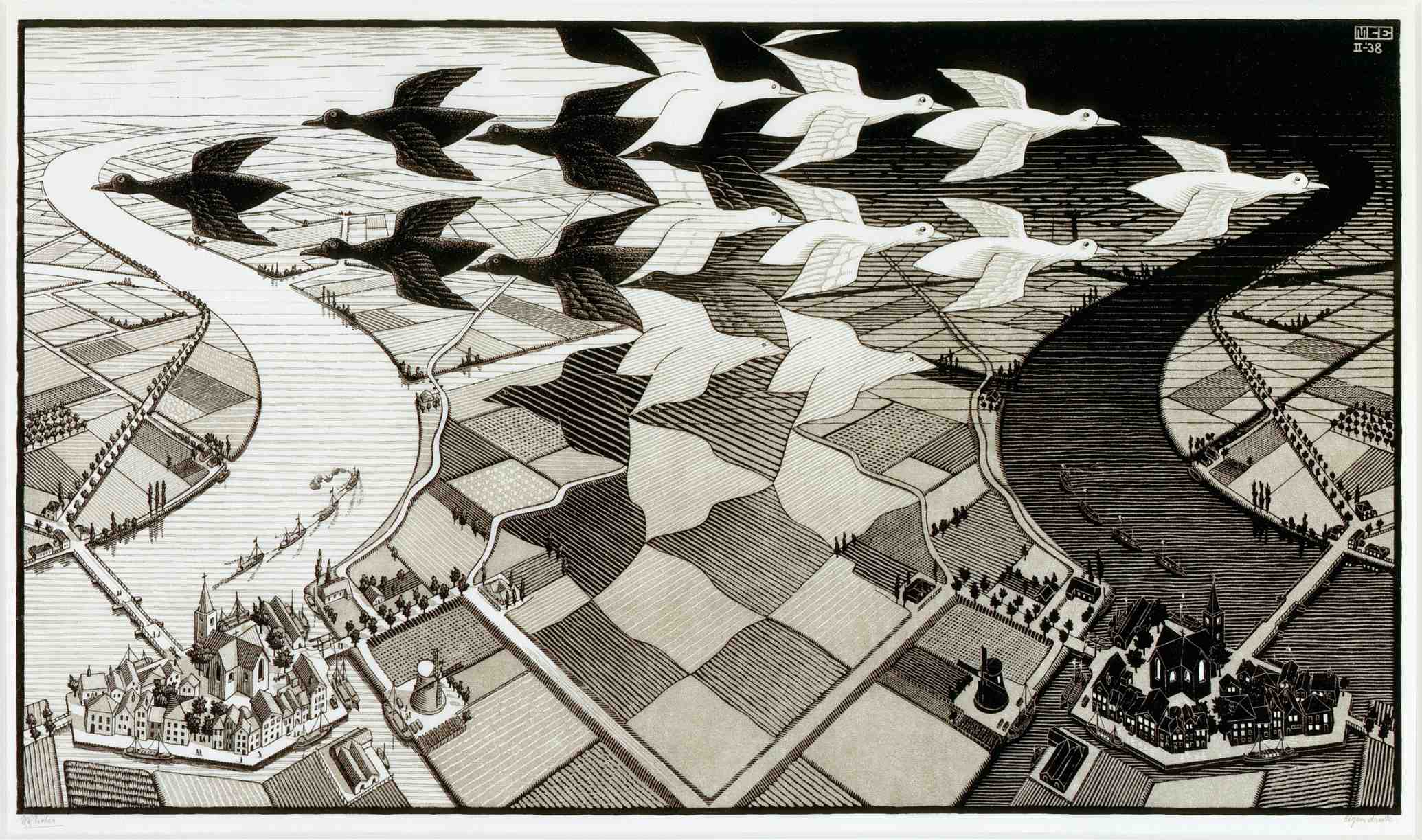
M.C. Escher: ‘Day and Night’ – possibly inspired by the Eem River valley landscape
It’s barely a river with its total length of 18 km and 10 km wide surrounding floodplain. But this little valley bears superb testimony to our fluctuating climate and to the creativity of humankind to deal with adverse conditions.

Figure 4. Digital elevation model of the central Netherlands, showing the terminal moraine of the Saalian/Illinoian ice cap and the River Eem, draining the interior moraine valley to the North. Source: www.ahl.nl. The western portion of the Saalian terminal moraine is known as the ‘Heuvelrug’, its eastern portion as the ‘Veluwe’. Even though the moraine was breached by melt water near at its southern tip, its inner valley drains mostly northwards through the River Eem and the ‘Lunterense Beek’, a somewhat longer river that is largely rerouted as a canal (not indicated on figure).
The Eemian/Sangamonian lasted only about 20,000 years, a relatively short time for an interglacial warm period. Eemian global mean sea level (MSL) stood ca. 4-6 m higher than present-day (Holocene) Mean sea level and global mean temperature was about 2degC higher than at present (the ‘present’ is changing rapidly of course). Of course, climate is warming and sea levels are rising rapidly since the last 200 years but it’s still safe to state that Eemian MSL stood about 2m above Holocene MSL.
When sea level rose during the Eemian interglacial, the North Sea flooded these lowlands and the bowl-shaped inner valley of the moraine became a shallow marine embayment, a natural receptacle for sediments washing in from the surrounding the inner slopes of the moraine (Figure 3.)
The moraine consists of gravel-loaded sands, loams and clays and was thus very susceptible to erosion prior to during early deglacation when the climate was still Arctic (tundra) and without much vegetation. Washed down slope sediments interfinger with marine sediments deposited in the Eem floodplain. This package of sediments tells us the story of the changing environmental conditions over time so well that it became the designated type locality for the Eemian interglacial.
After its short journey, the Eem empties in the former “Zuiderzee” tidal basin, renamed the “IJsselmeer” after it was isolated from the tidal sea by a 31 km barrier in 1932. The Dutch subsequently reclaimed a large portion of the IJsselmeer. The southern edges of these reclaimed land areas are visible in Figure 4.
Early people started settling here a little more than 1000 years ago. The town of Amersfoort (literally meaning ‘ford across the Eem/Amer, where ‘Eem/Amer’ means ‘water’) became a logical site for a trading post with the river Eem as its commercial access route as well as for beer brewing, thanks to reliable access to clear water. The river continued to have a commercial function until well into the 1960’s: when we rowed on the river in those years, we learned to manoeuver our skiffs in the wake of the barges that barreled empty and high upriver and full and low downriver. By that time, the river was very polluted: our parents warned us never to go swimming.
Because of its economic importance, it became essential that the river had a consistent water level and thus it became enclosed in artificial levees (‘dykes’) from the early Middle Ages onwards. The floodplain, now isolated from sediment-laden seasonal flooding, was pumped dry using windmills (first) and power-driven pumping stations (later). Its sediments compacted and its elevation sank to below sea level. It always remained relatively wet, however, and thus was and is used predominantly for grazing dairy cattle and for producing hay.
Times change – these days, the river is purely a recreational ribbon in the landscape. Also, dairy farming no longer has the economic significance it used to have. A significant part of the Netherlands is man-made; the country has an extremely high population density, so there is little room for nature. Changing economic conditions such as along the Eem are opportunities for re-instating a bit of nature: these days the floodplain of the Eem is allowed to regain some wetland characteristics, attracting large flocks of different species of geese, wild swans, herons and many other birds.

Small-scale water management in the Eem floodplain using wind and solar power. New wetland showing as water patches in the distance. Large-scale wind turbines on the horizon.
Growing up here, I never knew anything but a man-made landscape. I lived in the Anthropocene before that term was invented. The Dutch were and are hailed as the prime example of a people who have conquered nature. They must continue to do so if they want to keep their feet dry (2/3 of the Dutch population, ca. 10 million souls, live below sea level). Where possible, they now try to work with nature rather than against it because they have learned that the land otherwise becomes sterile. And they have become innovative in enabling the return of once considered worthless wetlands. They try to make room for rivers, some wildlife AND for green energy projects. It’s optimistic, it’s hopeful.
As I see it, the Anthropocene started here more than 1000 years ago. People continued to adapt to hostile circumstances and their adaptations have been novel and innovative and they have been able to improve them over time (the Eem floodplain was definitely not a bird sanctuary in the 1960’s). People are tenacious and creative, and this makes me hopeful about the future. Areas such as this can be an inspiration for well-designed interventions that will be needed to survive in the Anthropocene that now confronts everyone.
References:
http://en.wikipedia.org/wiki/Eem http://members.upc.nl/t.meijer64/paginas/ae-pub-eem_BCM.htm
Bosch, J.H.A., P. Cleveringa and R. Meijer, 2000, the Eemian stage in the Netherlands: history, character and new research. Netherlands Journal of Geosciences, v. 79 no. 2/3, p. 135-145. This article can be accessed at: http://members.upc.nl/t.meijer64/paginas/ae-pub-eem_BCM.htm
NEEM Community members, 2013, Eemian interglacial reconstructed from a Greenland folded ice core. Nature, 493, pp 489-494. http://www.nature.com/nature/journal/v493/n7433/full/nature11789.html
Vlaar, M., 2007, Reconstruction of the Palaeo-ecology of the Eem Polder by means of dendrochronology, pollen and macrofossil analysis. Unpublished MSc thesis, Utrecht University. http://vkc.library.uu.nl/vkc/archaeology/SiteCollectionDocuments/Scripties/2007/Marije%20Vlaar/MA%20Thesis%20Marije%20Vlaar%202007.pdf


Just wanted to leave a thank you note for your paleo map. I grew up in Soest (almost next to Eemdijk) became a geographer and Quaternary geologist and then moved to Canada (long story). Next month I am giving a talk to the New Brunswick Engineers at their annual meeting about Climate Change from an earth scientist’s perspective (subtitled “a matter of time”, as in time scale). It is peppered with some of my personal background but also how Dutch engineers live with the water (many examples).