The preamble to this review series is here.
—
Melling, H., R. Francois, P.G. Myers, W. Perri, A. Rochon, R.L. Taylor, 2012, The Arctic Ocean – a Canadian perspective from IPY. Climate Change, DOI 10.1007/s10584-012-0576-4. Published online at http://link.springer.com/article/10.1007%2Fs10584-012-0576-4/fulltext.html
The fourth International Polar Year, coordinated by the International Council for Science and the World Meteorological Organization, lasted from March 2007 to March 2009. It was a global scientific effort in which thousands of scientists from more than 60 countries collected data for more than 150 research projects, an enormous accomplishment.
Poles and oceans play a critical role in controlling climate, a globally relevant issue of which the details are still only partially understood. Big questions such as what parameters exactly control climate, how stable climate systems are and how quickly they can destabilize can only be answered through reams of minutely executed projects, defined on the basis of carefully articulated research questions. Eventually, the combined results of these effforts will lead to universally valid answers.
The Canadian contribution to this IPY was typically Canadian! Canadian scientists “wanted to contribute in a constructive manner to the larger international effort”. The Canadian IPY activities “were linked with those of other countries in order to advance Arctic marine science and move it closer to societal relevance, public policy and applications” and were focused exclusively on the Arctic.
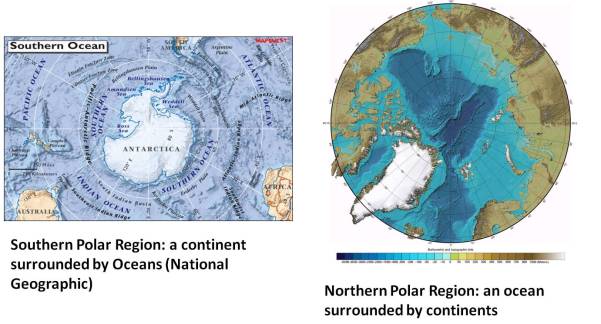
It’s important to be aware of how completely different the earth’s polar regions are. The North polar region is an ocean surrounded by continent masses, whereas the South polar region is a continent surrounded by ocean. You can’t think of more opposing conditions. Water absorbs heat in a much different way than land, so the Arctic’s role in governing climate is bound to be much different from that of Antarctica. In addition, the Arctic Ocean is unusual compared to other oceans because a relatively large portion of it is occupied by shallow (less than 500 m deep) continental shelf (light blue in the figure below). A continental shelf is the portion of a continent that is permanently flooded by the ocean. Shallow waters warm more easily than deep waters, so the shelves of the Arctic Ocean are like hot water bottles along its sides.
This article summarizes seven research projects that were carried out along a 13,000 km ship trajectory from Victoria to Halifax, traversing the three oceans that Canada borders (aptly named C3O). The ships from which the data were collected were Canadian coast guard vessels that were on their scheduled Arctic patrols. Talk about a win-win opportunity. Research is expensive, doing research in the Arctic is hideously expensive, so if you can reduce that expense by making use of paid-for ship time, you’re a genius in my book. By designing the research along this trajectory, the scientists established a baseline for future studies.
Quick primer to oceanography. If you have never thought about why and how ocean currents flow, there are two things you must remember:
- There are surface currents and deep currents. Surface currents are largely driven by wind (weather!), additionally pushed around by the rotation of our planet. Surface currents occupy the top 50-200 m of the oceans and their temperature is mostly controlled by the sun. Deep currents occupy the rest and since the world’s oceans have an average depth of 4000 m, that’s a lot of water that’s difficult to observe.
- The movement of the deep ocean water is driven by differences in density between water masses, again heavily influenced by the rotation of our planet. What causes density differences? Only two parameters to remember for the purpose of this blog post: salinity and temperature. Mean global ocean salinity is 35 parts per million (ppm). What makes for variability in salinity? Climate: in lower latitudes, average air temperature is relatively high, the water evaporates and the remaining water body becomes more salty. Salty water has a higher density than fresh water, so if the two come in contact, the salty water will sink below the fresh water. Warm water absorbs more gases from the atmosphere than cold water, hence warm water is less dense than cold water and thus cold water will sink below warmer water.
Do surface and deep water never mix? They sure do. To keep with the main topic of this paper, I will mention only the situation in the North Atlantic. There, the warm, salty waters of the Gulf Stream (named for the warm and thus salty Gulf of Mexico where it originates) meet cold polar waters. The salty water cools, becomes more dense, and sinks below cold (less salty) surface waters, then flows back South as deep water, supplementing the deep ocean with oxygen along the way. The linked system of surface and deep ocean currents is called the ‘global conveyor belt’, a term coined by the iconic oceanographer Wallace Broecker (Lamont Doherty Geological Observatory, NY).
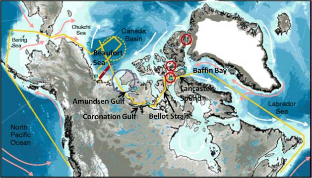
Now, let’s look at the 13,000 km study area discussed in this paper. This figure shows the trajectory and sampling stations of the Canadian IPY trajectories.
The Yellow Line is the ship track, officially called the C3O section. Other sampling stations (not discussed in this blog post) are represented by circles etc. Surface currents are represented by arrows: pink for warm, white for cold.
The Arctic Ocean is in contact with the Pacific ocean via the Bering Strait and with the Atlantic Ocean via the Davis Strait (between Baffin Bay and the Labrador Sea). It also receives a lot of (seasonally changing) fresh water from the surrounding continents, most of it from large rivers. On our side of the Arctic, these are the Mackenzie and the Yukon.
Because of a couple of unique conditions in the Northeastern Pacific, the water flowing into the Bering Strait is relatively fresh (lower salinity) compared to that of the Arctic Ocean. It’s also full of nutrients that support the food chain there. In addition, its elevation is about 40 cm above that in the Beaufort sea. As a result, the flow of ocean water from the Bering Strait to the Davis Strait is like a giant river flowing down an extremely gentle gradient. This “river in the ocean” receives additional fresh water from northern rivers, so it stays relatively fresh thus less dense along the way. In the past, it would gradually become more saline because of the formation of pack ice: when ice forms, fresh water is taken out of the ocean water body, thus increasing the salinity of the remaining sea water (and also reducing the temperature at which it freezes). But in the last decade, the surface waters remain relatively fresh and this expedition contributed to understanding why that happens
Here are the results:

The C3O section of seawater temperature (top) and salinity (bottom), measured in July 2008.
These diagrams are 2 dimensional (distance/depth) cross sections of the ship trajectory showing the variability of the two most crucial oceanographic parameters temperature and salinity. The vertical scale on these diagrams is pressure, which you can pretty much translate to depth 1:1.
Take a good look: the upper cross section shows the temperature variation along the trajectory. Clearly, the North Pacific is relatively warm (red). Once these waters enter the Arctic Ocean through the Bering Strait they remain recognizably warm until somewhere between the Amundsen and Coronation Gulf, nearly 8,000 km further. At that point, the surface waters become significantly colder as they become mixed with the relatively fresh, cold waters of the “Beaufort gyre”, a surface current that rotates in a clock-wise direction in the Beaufort Sea. Until a few years ago, the Beaufort gyre was permanentaly capped by sea ice.
The relatively fresh and recently ice-poor Beaufort gyre also influences the salinity along the same part of the transect, as shown in the lower diagram: from the Beaufort Sea to Coronation Gulf, salinities are only about 2/3 of mean ocean salinity.
These observations were supported by measurements on other tracers, such as the element Barium. Barium is a tracer of river water and its concentration was very low during the IPY observation years, which supported the conclusion that the observed freshening of the water along the transect was caused by influx from the changing position and behaviour of the Beaufort gyre.
Lots of other significant discoveries were made along this IPY transect. I can’t dwell on them more, or this post becomes as long as the article itself. Therefore only a short summary of the conclusions:
- the Canadian Arctic climate shows asymmetric cyclic variability in the last 10,000 years. During warmer intervals, there is less ice in the western Arctic and this coincides with more ice in the east and vice versa.
- Wind is a crucial influence on water movements
- When ice is far from shore, winds, waves and storm surges create hazardous conditions for coastal communities. Decreasing summer ice thus increases vulnerability of these settlements.
- Changes in the outflow from the Arctic to the Atlantic Ocean influence the global water cycle.
- There is more fresh water in the Canada basin during the last decade than before and this causes a decrease in nutrient supply, which affects the very base of the food chain.
Canada is one of only a handful of nations bordering the Arctic Ocean. Global climate is changing rapidly and Arctic research is more important than ever. It is therefore more than a little embarrassing that Canada still hasn’t moved on the replacement of its aging ice breakers, as reported here


